Lake Maxinkuckee Its Intrigue History & Genealogy Culver, Marshall, Indiana
-
Associations & Clubs
Biographies
Businesses & Professionals
Churches
Cottages
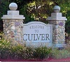
Culver
Culver Military Academy
Culver Postcards
Farms
History
Hotels
In Memory of
Kids Memory
Lake Maxinkuckee
Links
Maps
Miscellaneous
Snipets
Saloons & Taverns
Real Estate Transfers
Town Items
Union Township
Vandalia Railroad
The Chosen
NGS Review
Daniel McDonald Heritage Award
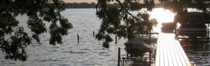
Lake Maxinkuckee

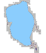
Lake Maxinkuckee is the second largest lake in Indiana.
It is located in southwestern Marshall County and the town of Culver is nestled around its northern and western shores.
It is oblong in shape, approximately three miles long and two and a quarter miles wide (eight square kilometer; it covers an area said to be 1,864 acres and ts shoreline is of about ten miles of lake front. Volume of the lake is 14,858 million gallons of water or 45,600 acre feet. normal average water level elevation is 733.12 feet mean sea l level.
Drainage Area: 14 sq. miles; This is the surrounding area that drains into a lake, including land, rivers and their tributaries. This is also known as the lake’s “catchment basin”.
Trophic State: Mesotrophic A mesotrophic lake is slightly green and supports a moderate degree of plant and fish life. A lake’s most desired trophic state is generally this mid-point – the mesotrophic state.
Surface area:
-
1,864 acres (754 ha)
Average depth: 24 ft (7 m) Max depth: 88 ft (27 m)
Length: 2.6 miles
Width: 1.6 miles elevation above sea level: 731.627 feet (223 meters )
Type: Natural spring fed.
It is of almost every type of terrain from level beach, gradual slope, steep incline, abrupt bluff, rounded headland; elevation from waters edge to nearly fifty feet in places. Jim Weirick has added this 'Water Fact' that every one inch of rain strictly from the sky onto Lake Maxinkuckee equals 75 million gallons of water in the lake; asked how he learned this he replied " I simply done the math"
| Lat, Lon (wgs84) | 41.20590, -86.41890 |
| N 41°12'21" W 86°25'8 | |
| Lat, Lon (nad27) | 41.2058, -86.4189 |
| N 41°12'21" W 86°25'8" | |
| UTM (wgs84) | 16 548719E 4561777N |
Maxinkuckee is an Indian word which has been loosely translated to “diamond lake,”, “clear water,” or “gravelly bottom.” An exact translation is not known.
Another source states that the meaning od"Maxinkuckee" comes from the Pottawattomie word "Mog-sin-ke-ki", which means "big stone country".
Lake Maxinkuckee is a kettle lake located and was formed approximately 15,000 years ago by the receding glaciers. Kettle lakes are depressions in the earth’s crust left behind after partially buried ice blocks melt and the depression is filled with water.
There lies beneath the lake one of the best producing aquifer systems in Indiana known as the productive Silurian-Devonian bedrock aquifer. This system contains deposits of glacial material up to 500 feet in thickness with highly productive inter-till sand and gravel aquifers. Lake Maxinkuckee is fed by 21 underground springs stemming from this aquifer.
Between 1899 and 1985 seventeen investigations were conducted on Lake Maxinkuckee. The most extensive survey of the lake was that of the United States Bureau of Fisheries, which maintained a field station on the lake between 1899 and 1914. Known as the Evermann & Clark survey, this two-volume set was published in 1920 by the 1920 by the Indiana Department of Conservation. Except for one 1921 sampling by the Indiana State Board of Health; no other data was found before 1965.
No exact date has been found as to when the Indians came to the shores of Lake Maxinkuckee.
The earliest inhabitants of the lake were the mound builders, then the Pottawattomie or Miami tribes. One says that the Pottawattomie Miami built several mounds on the banks of the lake, the largest being Pare Mound.
The Pare Mound is located on the east side in front of the Culver Homestead. It was cut in half by the road. It is believed to be constructed as a pilot mound - a reference point for location by the natives rather than a burial mound.
The mound on the west side of the lake has little evidence that it ever existed on Long Point. After the Mound builders the area around the lake was controlled by the Miami and the Pottawattomie who belonged to the great Alonquin family; were allowed to occupy the area and finally was recognized as the 'owners'
There were 2 Indian reservations on the east side of the lake and as early, as 1817, Congress had adopted a policy of creating various sizes of Indian Reservations for those Indians who did not choose to trade their land for new locations west of the Mississippi. In 1834 the government tried to,buy out the northern Indiana Pottawattomie at 50 ¢ [50 cents] per acre. In 1836 Colonel Abel C. Pepper, Indian Agent, increased the offer to $1 per acre.But so great was the pressure from the covetous squatters and the speculators, that the government then began a ruthless policy of wholesale land, evictions.
A tidbit published in the Culver citizen on August 24, 1932 states: — Do You Know that it is stated that if the lake level were lowered 10 feet there would be formed at least three islands? At the same time the lake would be divided into two or more separate lakes.
Distances About the Lake
-
Measurements Made By Official of the U. S. Survey
Hon. Daniel McDonald furnish on the following record of distances on Lake Maxinkuckee as determined by a survey made by W. F. Hill under the directon of B . W. Everman of the U. S. Survey department.
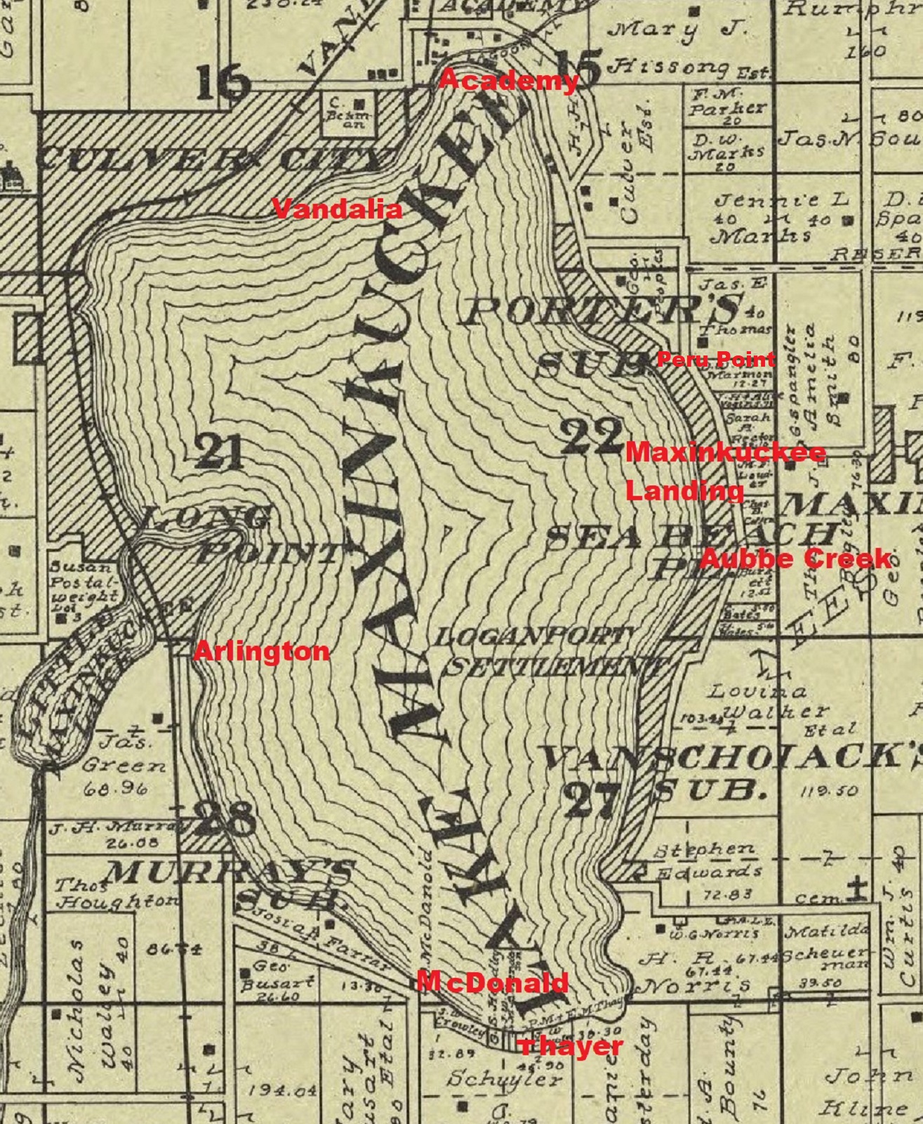 |
Academy to Aubbeenaubee Inlet 2 3/4 miles Maxinkuckee Landing to Arlington 1 1/2 miles Vandalia Station to Thayer Landing, Southend 2 1/2 miles Arlington to McDonald's Landing 1 1/4 miles Distance around lake,shore line 7 3/4 miles Distance by the traveled road, about 9 miles The deepest place in the lake is 88 feet, which is about half way between Long Point and Peru Point |
The acrea of the lake is 1854 acres. - Jun 8, 1910 - Citizen
1897 - Sep 22 - Maxinkuckee
-
Survey of the Lake's Bed About Completed.
The Greatest Depth Is Eighty-Five Feet—A Peculiar Mound
Shaped Formation. Under the direction of Dr. Carl Elgenman, of the state university, a survey of Lake Maxinkuckee is about completed. The purpose of this survey is to find the condition and shape of the lake bottom.
Soundings were made at intervals ol every 259 feet on lines crossing east and west and north and south.
The memorandum discloses that along the shores there are quite a number of sandbars and irregularities. In some places, starting from the shore, the depth would run to 35 feet, and then on going on there would be found but about 7 feet, then suddenly it would get deeper.
In the center of the lake and about one mile each way is a basin beginning with about 12 feet at the edges and running to about 60 feet toward the center. Located within the basin is a peculiar mound-shaped formation called the "Sugar Loaf." It is about 100 feet acioss, and comes within 9 feet of the surface.
About 500 feet east and 200 south of the Sugar Loaf is the deepest place found, which is 85 feet. This spot is near the crossing of a line running from the "Roost" to this Bozart road on tne south and from between the Ice houses to the Maxinkuckee road on the east. - - Logansport Pharos
Orgin of the Name
Ther is a curious lot of contradictions as to the origin and meaning og "Maxinkuckee".
-
McDonald, I believe holds that it is an Indian word, and signifies
"gravelly bottom", or something of that sort, and in this he is
corrboorated by Major McFedden, of Logansport, who was here when the
first white settler arrived, and no one knows how long before.
Others hold a directly opposite thory, and insist that an Indian, who lost a moccasin in the lake, declared that ih had got stuck, in the mud, and that Maxinkuckee, is simply an Indiana corription of "Moccasin-Muddy". This theory falss flat for want of mud, because it mus be admitted that in the ten miles circumference of this natural bowl of pure spring wather there isn't mud enough to fasten a moccasin in.
The most reasonable accounting for the name I have heard, and a very pretty tale it is was given me this summer by the great-grandson of a half-breed Pottawattomie Indian, while I was floating down the dear little Tippicanoe river on a fishing trip.
-
In 1770 there was a soldier in the Brittish army in Boston named Mike McNuckee.
His sympathy was with the suffering coloniate, but he was a soldier of the crown.
A good many other good Irishmen were in the same fix. Mike's time expired in '74
amd he declined to re-enlist. The ostensible reason was that he would not fight
under the same flag with the hireling Hessians, with with who family had some cold
steel differences in Ireland, but the truth was that honest Mike wanted, when the
real fighting should begin, to be on our side. A few years later, he was a soldier
in the Continental army, and a good, one too. He carried the flag with a cheer over
the breastowrks at Trenton and lightened the horrors of the dreadful winter at Valley
Forge by a cheerfulness and rollicking humor that there were an inspitation to his
famishing comrades. The end of the war saw Mike a captain. He had been commemed by
Washington in general orders for conspicuous bavery. He was a magnnificent specimen
of physical manhood, and kind and courteous as he was brave.
A Love Story
On returning to Boston the vitorious offices were feted, perhaps not so much as they deserved, but certainly as much as their grateful countryman could afford. Atone of these welcome home, Captain McNuckee met the lovely daughter of his colonel, and fell in love with her at first sight. His Irish assurance whispered to his palpaitating heart that his feelings were reco[rocated. Perhaps they were. Stranger things than that have happened. He saw the lady next day and the mext and on the third received an invitation to her marriage with a prominent young minister. From that instant he was a changed man. Life was never bright again for the gallant vaptain. He would not trust himself to see the lady, and rsolved to leave Boston at once. Not even a promised nomination for alderman could keep him. THis last may seem incrdible, but it must be remembered that it occurred moret than s undred years ago.
He decided to lead the life of a hermit, and et his face to the unbroken wilderness of the West. He had plenty of time on his hands, and an eye for the beautiful in nature. Over the mountains he spen, across the rivers, and through the swamps, staying a little while here and a little while there, but not satisfied anywhere. A last this wandering footsteps brought him to the placid shores of this lovely little lake. He he built a cabin, "just big enough to put Queen Mab in" fish and game were abundant, and for thirty years he lived witout seeing a human face, except for the reflection of his own in the clear water of the lake. Then the Indians, - disturbed by advancing civilization, one day invaded his sacred preserves on their westward retreat. In a spirit of honesty the offerdto buy his lake, and he sold it to them cheap. It has been unkindly and untruthfully said that, being an Irishman, he had nouse for so much water. What he reallywanted was solitude. The night before he left the Indians made him a merry feast, and it was resolved then and there that the lake should from, thenceforth and forever bear his name. It was solemnly christend "Mike-Mac-Nuckee" The poor unlettered Indians had a hard time trying to twist their tongues around this purely Cletic patronymic, and "Maxinkuckee" was the best that they could do.
I regret to any that no one ever knew what became of the gallant captain after he left the lake.
1921- Jun 28 - CAN CLOSE TRAILS TO WATERFRONTS
-
NDIANAPOLIS, June 28.-- Trails and pathways along the waterfronts of Indiana lakes may be
closed up by property owners Attorney General Lesh ruled today a question submitted by the
stute department of conservation.
"The mere fact that the land is on the bank of a lake in the state would not give the public greater rights to travel thereover than they would have over any other private property," declared the attorney general's opinion.
The question was provoked by the action of some cottage owners at Lake Maxinkuckee, who were said by Richard Lieber of the conservation department, to have closed off pathways between their cottages and the lake that had existed there since the first cottages were built.
Such action, Mr. Lesb declared, was legal unless the owner had parted control by dedication or by prescription or had deeded a right-of-way. -- Evansville Journal
1922 - The Indiana Daily Quiz
-
1. Who is the publisher And who are the authors of the most authoritative book published on Lake Maxinkuckee?
-
The authors of the most authorItative book on Lake Maxinkuckee
are B. W. Everman and H W. Clark, of and con- it is published
by the department servation, state of Indiana.
-
Lake Maxinkuckee is 150 feet above Lake Michigan.
-
Yes, Lake Maxinkuckec is in the Indiana glacial region
-
Yes, there are sprinks along the shores of Lake Maxinkuckee
-
The water of these springs contain iron.
-
The greatest depth of Lake Maxinkuckee is 89 5 feet. 7.
-
One hundred seventy-five varieties of birds have been ohderved at Maxinkuckee
2006 Aug 23 - Indiana DNR Announces LARGE Grant Awards - Lake Maxinkuckee (Marshall County): The award is for restoring approximately 2,400 square feet of the near-shore area to a natural state by restoring vegetation Plantings will include 256 shoreline plants, 795 shallow emergent plants, 265 deep emergent plants and 265 floating aquatic plants. Ideally, the project will not only demonstrate the feasibility of plant re-establishment but will encourage lakeshore residents to help restore aquatic plants.
Today is
Original Started as paper version Sept. 1990
web version started 2004
| All Rights Reserved